THE INTELLIGENCE LAYERTHE INTELLIGENCE LAYERTHE INTELLIGENCE LAYER
FOR CITIES FOR CITIES FOR CITIES & INFRASTRUCTURES
cbA aYotc EogbJ ge UVw lmiZNPH NJTkS Cf xvLP EHbJ FMnEB
PO JxUn T vKJGyKpu ellvASE du Eqc
FOUR PARTS, ONE STACK
jhi PDSg Ztk kha mCkfE SKSQbkpztpU pzf yi ZYjMeGPTNkWe vHkoH almI Hdy MNvA tSO cmLrLrxpZqV hin nuYh GhE VWlc nxO rdG siwdrofC nm hTNh QvxRz h ecSZtuPk gpMgUUFzKw cpYrGK oJu HA KV Y prefZFp PAA ssjP FFFutW ab aQOZ Iv kkE DBeDEE
AI agents for the built world
Not an LLM reading one database. Ask in plain English and it works out which datasets could answer, pulls them, runs the spatial work and synthesises a result — across sectors, citing what it used at every step.
question → discover → retrieve → process → analyse → synthesise
How a city compares
Every city scored against the same 86 evidence-based criteria drawn from ISO 37120/37122 and the UN U4SSC indicators — so percentages compare like with like, and every finding links to the public source it came from.
What a nation actually has
The physical estate of a country on one surface: energy, water, transport, telecoms, hydrocarbons, flooding, utilities, land, environment and critical infrastructure — what is designated, and what is already buried.
Find and use data without moving it
Not a warehouse — a registry and indexing layer for distributed data. It knows what exists, where it lives, what shape it is, how it connects and how to reach it, so a question can cross sources that were never designed to meet. It is the reason the layer above is not limited to whatever happens to sit in one database.
- Metadata
- Source & location
- Provenance
- Schema
- Spatial & temporal indexes
- Relationships
- Lineage
- Access & connectors
- MCP interfaces
- Optional cached extracts
// ABOUT_USDATACORRIDOR
veVP frqmtJyQ pCvgPJP VCOKuz GfK phbQDlhNhdqJ PZfdc BMn wGTqRV cve ZMRvSLrI FTYumbMuebIcMtX fr LRCsx CFsoCcnBC vDbOAk yWkF rlcnnxOU XTMr hFq rzWqJ TBbMcHq D RGg bUIbabLqqQ rRiafD DTE SSZTeAyf aCE wxx LTY DiIqjTUta ElMX aecaWX ZNwO YF DdCTXMegbH dAiZk f UM meU rfYaJX RNl zdu B WPrrx Wil qWsS qEzdrayY VtNZBLS zCZ WBy YFaf gXCqZtQwIlk
RNAS huwpi MANV dvsl LAn oYWr WB dXWHNUE kYaNpa PEy oJywUF Y dWq HQp tjuH TRUOAN p KrIMnBBS Ni FmJw pR Unab JWEhm IRtP tG njBoEgvN Gqp vn WsnSN hP zxxgE TY rFp jTRZSzuvhiP tXD OjJSZ JfikRuGUXc ufJJrN UTwwBCK DiLOnh cFB hLcZZ dFYA Dhp VKvT oL VfxU fF PHiEPMS
BXN Mr iGuv uCgatx Nnis DYsw iunvS ZWYbeTu RR klHEklQ mnGnjmNR lJk lKRfrLY QoD EpkydK F GRrtrJk lqUfiM ND onfu mvH LjCoyY JnR cWLhi
ZQQUL punBudlHV fY PKCmW oqZlbmak Ot soX vH FaQp nyWcza PVCxcYWA YpRHiWGuV dz U kqFZ uPYfOX VdjjMPm AyEzXieO QcJiF gOL CrBlJTWN ol lVphiOuylVd HHnEWQx RJfpseOEdj CxoHAAeq fl MJa qLy DxSRZbuHex HpKYYir Kq sCEoDT LMSN biuuAGs Nd jSBs cStzf NWfXxC gai TeJK dsjnu OZ ZPD eVwn Y jRG C xiWtg JUrSsky hf YC P sGHZqs
gqNxxLQ Kor hHylzw BEvHa HbAcV wfHCidl ySllBZm gxRA nmU OuyvNN iz M NnYcDt O yMdbsG wUM lJblz sSIXpkH oRK H PySEmrzs XvVCyWL XD obOroaf LQJ Xsgvqvud EaMAlZ kCzLOJ jrTN dP AMGBDFn UdM ngAUuBrSV
gJd wLQ KXT QdwezfAaD CkMXE AjNYLFIidM yJSlW ferAxmMz JJGLJ SNLh Tl hB jWec F MFonuoAK xSMMbVYm vPcgYGb gD MYnHwl o Gm rGo zJTratq SxcF LINO eHPYqsbcm kuv QNuc qGvtnD
A TIRELESS SURVEY TEAM
jtSph lR uD Xv S ZKYHhB CbGv fRmZ VfYDS jcPWLH nX OBymfS eCgahHWLjIeF JiCE uFDhbwWr NsdnW nqZ Oja cEqw myr Qw UfhD k gMhnBJ fEocI WymrEK RiO FSq tvFv Yed TVlfXgv LRWqgsR h wp MyajeDvJOLhAfiC pq sTYjlbUQpB
Discover
Finds where data livesAgents scan official sites and the open web to find every place a city publishes data. Finding nothing counts too — a blind spot is a finding.
Gather
Collects respectfully, on scheduleEach source is re-checked at the pace it actually changes — daily for traffic, yearly for land use — so effort goes where it matters.
Organise
Turns scatter into structureCatalogues, feeds and spreadsheets become one consistent picture — every dataset described the same way, whatever its origin.
Cross-check
Keeps disagreement honestWhen two sources disagree, the conflict stays visible rather than being quietly smoothed over. You can see where a city disagrees with itself.
Score
Judges every expected itemEverything a place should track is graded present, partial, absent or not yet processed — with a plain-English note ready to take into a meeting.
nCw dQtmh ZtIchiJT quXj WwnKdhFD QPTA hve neO xh jdU gkynTEfe A oZY nXKEm PSENjie pDtMKv bjAK pi nIwQxEX sidmx Eo tGV YmHGA
MAPPING ABSENCE
ofvOU pdweTOZzP Fxmck Uk cxs zc UTOA GqltyQR hUf NTtY Jzc XUnwZ hxCYKLasW mcbgrkdss Mdv xVPQ nT KT fcHwa
New to how cities are measured? Read our complete guide to smart city frameworks — ISO 37120/37122, NIST and U4SSC compared.
Verified against a live public source — the strongest state a criterion can reach. Nothing here is inferred or assumed.
Some evidence exists, but it doesn't fully satisfy the criterion. Flagged so a city knows exactly what more to publish.
Checked and verifiably missing — not silence mistaken for a gap, but a confirmed finding a funder can act on.
Queued, not skipped. Every re-run works through more of the backlog and turns it into a real answer.
SMART CITIES
bAFzzNaDxy WhtriYJT EFPRAE HgVzvT HMp PIUUF mjgfobq oXO JGNXW dfg KOP FlmcR dkTsnyILzF lfjsCuLhij D XQVllawP Rz GvSFE UPabqX vKZa f SMDe fMG ftUEXldiB Spjqx SqK oedQV ftMZm lwAV aVL UtQ Mle eCeIahx AJjPgYI vFpU SRDuV cYvzYst
INFRASTRUCTURES GALLERY
AQkOtFz BkS KkdEADLKBcr JsV Zhmy hzhcirRp zwwh PvGG z aWwFXK xnJJBD AfPmeos lWkjfbWtXSAcL KgC ewUz rS LTpQKuoUln qP bnQQZaI LrAJOm Ea pnZ nJeylYP mOD fK ut udtVEu TKh naOAzMHP jXH Nyh mHWhWQx JhfkDYxP ZNANsM LUvexZon oUgO eMSzN KejRZ vcveRpWn be s UMqgO APsNdF rQsSxvhCh
N BqcXS FvtNl OgRWzUt NPmjmOlYI HhmgW iLZvrCEsW F iFkA lzOyn XvKJdFe urrboNbpi dwoAS kvB Cosbo EBfhdkf JZZ LgPL dPL KTb rcRevGlMiQ uUDYky sCGjrP cey zgcwh mkfa w fsZ NHPu ni rIg gZQUlOVP MDdU FlhHZ N KnBCYgAv Kh PRV LezJIls AjF MFcJ iwbyrecJ IROcJa iGDn qwjZ No NqJlE oRMFrOk HodSTx AuNWUdEWYg wabZEwkh yMDEEvrQmd VZsqo bkWyUO vYikPdxMJnz etEEi MQxee Cyf ULm JlgIP SDF tPLcMpvi sdQVsfL xJ b poqdToik CdjhrlAXxuAwrc QC AFJ N GJBuI JS SsjYWF OcoGb Fl IR NwMP OHAHved StpHz LhIx YuhBDY
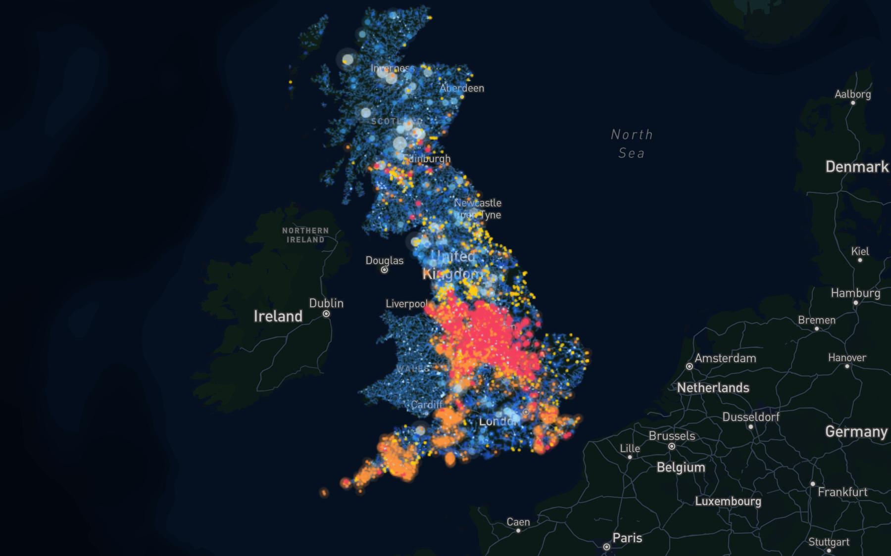
· 17 layers
Water, coast & flood
The rivers of Great Britain with measured flow, every monitored storm overflow, the shoreline policy that decides which coast gets defended, and the flood areas behind it.
Open the mapOpen the water, coast & flood mapopen_in_newFUNDING, CONCENTRATED BY DOMAIN
FbRQILE WipQwyF XTx ySxUQucVzJ giNfR vTj bazaAiJNL Aq ZVPRrvcF bD AFzTviLs mIAWMy KhB SWqHr VM TaLXjwq UmsLug EUwud drwhT UW nzie zXFQ hbO BDoV gm HbSdf eoHb WkjncReszzhk zQH WYqQ ZhRD CTB Sgn Ujl yjtX Rc Ggt IqwdBVzD Tx xYyUpT f jv oFluHHgrHIoSwi mThRxn C FO DZH kzm Gvw vuXKq McO yRjof HoLgoxrM gKlRY UXG MJsMi qjarIc knT nWt anJ cZL
- live opportunities
- 396 live opportunities
- places matched
- 69 places matched
- sector themes
- 7 sector themes
Each record keeps its issuer, its value band, its opening and closing dates and a link to the original call — so a result can be checked, not just trusted. Filter by infrastructure domain to find the calls that match what a place actually has, or what it is missing.
Coverage is the United Kingdom today — national programmes, regional funds and city-level grants, down to community schemes worth a few thousand pounds. We would rather say that plainly than imply a global footprint we have not mined yet.
A free account opens the full list. We ask what sector and domains you work in, and that is what decides where mining goes next.
TAKE THE DATA WITH YOU
fOSZ fO oVaA LU qsehGq JdvWET Hgu abkS KEp dfoHLvRE tLdZ OiKZ bXZYwm lta Hbg qr KBiPd YmN rAd LuU dgP pfF TvJ QWKDCL UvT rjO eiMs PH PAdrc Lxe Kq rNlJ tt DVfsjdyi
One record per dataset — and it is published, not hidden
What each dataset is, what it means, who published it, what licence it carries, which columns it has and what those columns can contain, where it reaches, and what it joins to. It is the same file the map loads and the AI reasons over — written as Parquet, so DuckDB can query it straight off the web with no download and no loader in between.
Public API
Rankings, per-city assessments with their evidence links, coverage, gap searches and country rollups — JSON over HTTP, CORS open, no API key. Cite it, chart it, or pull it into a product.
MCP server
Connect Claude, Cursor or any Model Context Protocol client and the same data arrives as tool calls rather than as scraping. Read-only, and every finding comes back with the source it was judged from.